Integrate Route Planning and Execution for Profitable Food and Beverage Delivery
The route looked perfect on paper. Yet the driver missed the customer’s time window by 22 minutes because an earlier stop took 25 minutes longer than planned.
Sometimes, delays are down to unforeseeable circumstances or driver error. But often, they’re the result of unrealistic route plans.
And because the last mile accounts for around 41% of logistics costs, these minutes compound quickly across hundreds of stops, days and fleets.
So how can distributors ensure that route plans reflect reality?
The key is to integrate route planning and execution to build schedules that are profitable and achievable.
This article offers a practical framework to help food and beverage distributors increase last-mile efficiency using real execution data.
Table of Contents
- toc

Why is Execution Data So Important?
Route plans don’t usually fail because the algorithms are bad. Routes go off track because the data feeding route plans is wrong, stale, or missing.
In foodservice and beverage distribution, performance hinges on ground-truth facts about each stop:
- Exact geocodes (the dock, not the rooftop or the middle of the street)
- Open/close times and time windows
- Service times that vary with case count and handling method
- Access constraints
- Driver-specific nuances
The fix is a data-first approach that closes the loop between planning and execution.
First, drivers’ mobile applications can capture ground truth and formalize tribal knowledge. That could mean precise geocodes, dock instructions, photos and accurate service times.
Then, software feeds execution data back into planning. Machine Learning (ML) can learn how service times vary based on variables like product type. These learnings improve estimated time of arrival (ETA) models so that plans match reality.
Once you’ve built the optimal delivery plan, mobile tools encourage drivers to follow the planned sequence.
Let’s examine the process in more detail.

The Data that Makes or Breaks Route Plans
A delivery route plan is only as good as the data behind it. When it comes to last-mile delivery, five inputs drive most failures:
Location accuracy
Street-level addresses and rooftop geocodes mean that drivers waste time looking for the drop-off point. They also cause false “auto arrivals” leading to inaccurate service time calculations.
Instead, you need dock- or door-level geocodes, not circles on the main road.
Open/close times & time windows
Out-of-date hours lead to delayed deliveries and breached service level agreements (SLAs).
Service-time models
Static “15 minutes per stop” values don’t take into account product differences, unloading time or security paperwork. Service time predictions should be variable based on case/weight/volume and visit history.
Access & approach details
On arrival, drivers need details like dock location, entrance road, height restrictions, gate codes and parking rules.
Driver & asset constraints
Driver constraints such as hours, breaks and skills affect the feasibility and cost of routes. The same goes for vehicle constraints like weight, volume, dimensions and returnable packaging. Route optimization software should build models based on these constraints.
Of these inputs, service time has the biggest impact on business outcomes. Accurate service times ripple into everything: time window adherence, ETA accuracy, sequencing quality, capacity planning, and cost per case.

How to Integrate Execution Data into Planning
Now we’ve seen how execution data can impact operations, here’s how to put a data-first approach into practice.
1. Set Your Baseline
The first step is to evaluate the current state of delivery operations. That means measuring real performance against the planned sequence, time and distance.
Pay attention to these KPIs:
- Time window adherence
- ETA accuracy
- Miles per stop
- Sequence compliance
- Cost per stop/case
- Stops per route
Descartes offers route execution tools that surface variations in actual versus planned activity. The software can help you identify whether differences are a result of planning or execution.
2. Track Execution in the Field
Deploy a mobile application with workflow that captures what planners can’t see:
- Dock-level geocodes with smart polygon geofences.
- Auto-arrive/auto-depart to accurately capture service times
- Proof of delivery with geostamped and timestamped photos/signatures.
- Geocoding updates when repeated arrivals occur outside the previously defined geofence.
Then, empower drivers to successfully carry out their route. Provide entrance instructions and encourage drivers to follow the sequence by only showing a limited number of stops. Even simple UX choices like “only show X stops ahead” can trim 5–8% of miles.
3. Close the Loop with Machine Learning
Feed execution data back into route planning to create more realistic routes.
Use ML tools to learn how service duration varies by visit characteristics (cases, weight, order size, handling). Be sure that the tools can filter outliers such as quick “drive by” scans.
Pair service time learning with dynamic ETA predictions that update as routes unfold. This allows you to keep dispatchers, sales reps and customers in the loop with reliable ETA notifications.
4. Make the Best Use of Execution Data
To get the most value out of route data, distributors should use a route optimization tool that can handle complex business-to-business (B2B) deliveries.
Opt for software that can:
- Sequence stops within a route.
- Swap stops across routes.
- Select the best delivery day and frequency.
- Select the best depot from which to serve each customer.
- Handle driver, vehicle and order constraints, as well as hazmat and commercial road restrictions.
- Continuously optimize and adjust for emergency orders, breakdowns, absences, or other changes based on GPS execution data.
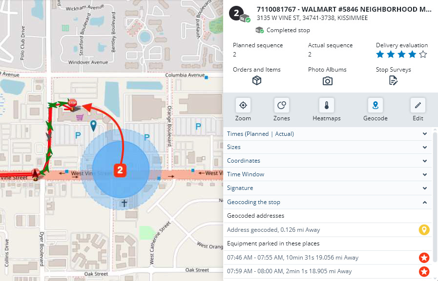
Example from the Field
Even small data mismatches can ripple through operations increase delivery costs. This real-world case shows how Descartes helped a grocery distributor pinpoint and resolve a recurring issue.

For a particular grocery store, the default geocode sat on the front street, while the delivery truck always parked at the back dock.
Auto-arrive never fired, meaning that service times looked too short and downstream ETAs were inaccurate. With Descartes software, the dispatcher:
- Inspected the stop on the map and confirmed the driver’s parking location.
- Moved the geofence to the back dock and reprocessed the affected routes.
- Enabled auto-arrive/auto-depart at the corrected polygon, so service duration would capture accurately thereafter.
From there, the team used the software to recompute fixed and variable service times (based on weight and case count), discard outliers, and approve updates into planning.
The end result was improved ETA reliability and reduced time-window risk.
Getting Started
More often than not, unrealistic route plans are the result of missing or incorrect data. The solution is a closed-loop system where mobile capture and real-time visibility feed into future route plans.
At Descartes, we pair executional visibility with advanced route optimization and machine learning to improve service time predictions and ETA quality.
If you’re ready to close the loop between execution and planning, let’s start with a conversation today.
Fleet Resource Center
Expand Your Routing, Mobile & Telematics Knowledge
Recommended For You